Mykines, Greece
Jump to navigation
Jump to search
Mykines Μυκήνες | |
|---|---|
| Coordinates: 37°43′N 22°45′E / 37.717°N 22.750°ECoordinates: 37°43′N 22°45′E / 37.717°N 22.750°E | |
| Country | Greece |
| Administrative region | Peloponnese |
| Regional unit | Argolis |
| Municipality | Argos-Mykines |
| • Municipal unit | 159.0 km2 (61.4 sq mi) |
| Elevation | 75 m (246 ft) |
| Population (2011)[1] | |
| • Municipal unit | 3,388 |
| • Municipal unit density | 21/km2 (55/sq mi) |
| Community | |
| • Population | 354 (2011) |
| Time zone | UTC+2 (EET) |
| • Summer (DST) | UTC+3 (EEST) |
| Postal code | 212 00 |
| Area code(s) | 27510 |
| Vehicle registration | AP |
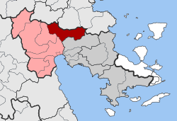
Mycines (Greek: Μυκήνες), known before 1916 as Charvati (Χαρβάτι),[2] is a village and a former municipality in Argolis, Peloponnese, Greece. Since the 2011 local government reform it is part of the municipality Argos-Mykines, of which it is a municipal unit.[3] The municipal unit has an area of 159.033 km2.[4] It is located 1 km west of the ancient site of Mycenae and 2 km east of the highway linking Argos and Corinth. It is 9 km north of Argos.
Name[edit]
The village is near the archaeological site of Mycenae.
Historical population[edit]
| Year | Community | Municipal unit |
|---|---|---|
| 1981 | 440 | - |
| 1991 | 436 | 4,412 |
| 2001 | 422 | 4,349 |
| 2011 | 354 | 3,388 |
References[edit]
- ^ a b "Απογραφή Πληθυσμού - Κατοικιών 2011. ΜΟΝΙΜΟΣ Πληθυσμός" (in Greek). Hellenic Statistical Authority.
- ^ Name changes of settlements in Greece
- ^ Kallikratis law Greece Ministry of Interior (in Greek)
- ^ "Population & housing census 2001 (incl. area and average elevation)" (PDF) (in Greek). National Statistical Service of Greece.

